FishAngler: Fishing Maps App
- 4.2
- Rating
- 1.00M
- Installs
- Free
- Price

 Analysis by App-foxy
I usually judge a fishing app by one simple question: does it help me make better decisions before and during a trip, or does it merely put a few familiar tools behind a busy screen? FishAngler: Fishing Guide App is more ambitious than a basic catch log. It is a free sports app from FishAngler, LLC that brings together fishing maps, forecasts, and AI-assisted fish identification, with a social layer built around anglers sharing what they find. After spending time with it, I see it as most useful for people who want one place to plan, record, and learn from fishing trips rather than switching between a weather app, a map, a camera tool, and handwritten notes.
The important word in that description is “free.” You can start using the app without paying an upfront purchase price, while optional in-app purchases are listed from $6.99 to $49.99 per item. That makes the first step easy, but it also means the real value depends on how much of your normal fishing routine fits comfortably into the free experience and whether the optional extras solve a problem you actually have. I would not treat the purchase range as a reason to spend immediately. I would use the free access first, learn which tools become part of my routine, and only then decide whether an upgrade is worthwhile.
How FishAngler fits into a real fishing routine
The app makes the most sense when I use it as a trip companion instead of expecting it to replace my own judgment. Before leaving home, I can look at map-based information and forecasts to narrow down where and when a trip might be worthwhile. At the water, the same phone becomes a reference tool for identifying a fish and keeping a record of what happened. Later, those records can help me notice patterns in my own outings rather than relying on memory.
You May Also Like

 Blood Strike: 2.5 Anniversary
Blood Strike’s Loadouts Turn Every Drop Into a Tactical Gamble
A close look at Blood Strike’s custom loadouts: how fast access to signature weapons reshapes its battle royale rhythm, rewards preparation, and narrows the gap between fights.

 Pandora - Music & Podcasts
Pandora’s Music Is Easy to Start, but Harder to Recover
Pandora’s strength is its low-effort path from a seed to a station. Its weak spot is how much confidence it asks you to place in connection, setup, and quiet recovery.

 8 Ball Pool
 Is Built on Rivalries, Rematches, and Routine
A close look at the rivalries, rematches, shared routines, and unanswered safety questions that turn a quick pool match into a persistent mobile community.

 Samsung Music
’s Quiet Strength Is Playing What You Already Own
Its reach comes less from spectacle than from dependable access to a personal library. That simplicity is both the app’s strongest retention engine and its ceiling.

 AccuWeather: Weather Radar
AccuWeather Review: A Quick, Clear Forecast for Everyday Decisions
For everyday plans, the best forecast is the one you can understand quickly. AccuWeather makes rain timing, radar, and local conditions easy to act on, with a few trade-offs.

 Hill Climb Racing
Why Hill Climb Racing Still Turns Crashes Into One More Run
A tiny car, a bumpy hill and one more upgrade: Hill Climb Racing keeps resurfacing because its simple chaos makes every near-miss feel personal.
More From Our News Desk



That workflow is more useful than opening the app only after catching something. Fishing decisions are often made in stages: choosing a location, choosing a time, adapting to conditions, and then remembering what worked. FishAngler connects those stages. It does not magically tell me where every fish will be, but it gives me a structured way to prepare and reflect. The strongest value is the connection between planning and learning, not any single feature viewed in isolation.
I also like that the app sits in the sports category rather than presenting itself as a general travel or weather utility. Its focus is clearly fishing, so the information is organized around an angler’s questions. That focus can save time on a weekend morning when I would otherwise be moving between unrelated apps and trying to combine their information myself.
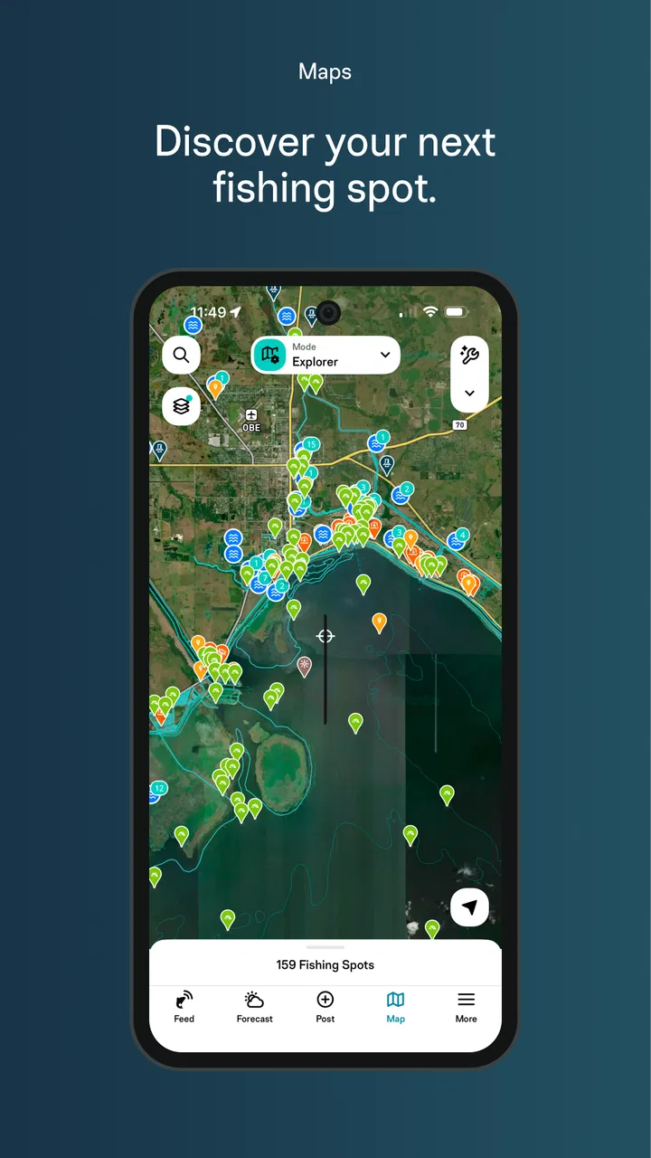
Maps are most useful when they support a decision
A map is only valuable if it helps me choose between realistic options. With FishAngler, I would use the map before a trip to compare familiar spots, check what information is available around a new area, and mark the places I want to revisit. The practical benefit is not simply seeing points on a screen. It is building a personal reference that becomes more useful as I continue using the app.
One of the less obvious advantages of a fishing-specific map is that it encourages me to think in terms of conditions and outcomes. Instead of saving a location because it looks promising, I can treat it as a test: what was the weather like, what did I catch, and would I return under similar circumstances? That mindset makes the app more valuable over time. It turns a collection of locations into a personal decision-making aid.
There is a trade-off, though. A digital map can make a fishing area look more certain and complete than it really is. Shore access, water levels, local rules, private property, seasonal changes, and safe parking still require independent checking. I would never use a pin or forecast as permission to enter a place or as a substitute for local knowledge. The map is a planning layer, not a guarantee that a spot will be accessible, productive, or legal.
Forecasts help with preparation, not prediction
The forecast tools are useful when I use them to prepare equipment and expectations. A changing day might call for different clothing, tackle, or timing than a stable one. Seeing conditions in the same fishing-focused app can make that preparation more deliberate, especially when I am comparing a short morning trip with a longer outing.
My advice is to check the forecast more than once: once while planning and again before leaving. Conditions can change, and the best use of the forecast is to adjust the plan rather than treat it as a promise. If I am deciding whether to travel a long distance, I would still compare the app’s information with a trusted local weather source and use common sense around wind, storms, heat, and water safety.
This is also where the app may be less useful for experienced anglers who already have a preferred weather service and a well-established way to interpret it. The convenience of having fishing tools together is real, but convenience is not the same as superior forecasting. I see the forecast section as a practical part of the overall workflow, not a reason by itself to choose this app.
AI fish identification is convenient, but I would verify it
The AI fish identification feature is the kind of tool that can be genuinely helpful in the moment. A new angler may recognize that a catch is a fish but be unsure of the species, while a more experienced person may encounter a look-alike and want a quick second opinion. Having identification available inside a fishing app also makes it easier to connect the catch with a record instead of forgetting the details later.
I would treat the result as an assistant, not an authority. Photos can be affected by glare, poor lighting, unusual angles, water, size differences, and similar-looking species. Before keeping a fish, handling a protected species, or relying on an identification for local regulations, I would verify it with a regional guide or official source. That is an important limitation, but it does not make the feature pointless. It is still useful for learning, organizing catches, and deciding what to investigate further.
A good workflow is to take a clear photo from the side, avoid covering distinctive markings, and compare the suggested identification with the fish’s visible features. I would also record the location and conditions at the same time. The result is more valuable than a label alone because it creates a small learning exercise: I can see whether my first impression matched the app and gradually become better at identifying local species myself.
Logging catches can turn scattered memories into useful evidence
Many anglers remember the exciting parts of a trip but lose the details that would help them repeat the result. A catch record is more valuable when it includes context: where I was, when I was there, what the conditions felt like, and what changed during the outing. FishAngler’s combination of maps, forecasts, and identification encourages that kind of recordkeeping.
I would not try to document every minor detail while actively fishing. That can distract from the trip. Instead, I would make a quick note or capture the essential information immediately after a catch, then fill in anything else later. This is one of the most practical ways to use the app: keep the record simple enough that I will actually maintain it.
Over several outings, those entries can reveal personal patterns that generic fishing advice cannot. Perhaps a certain area is productive only during a particular type of weather, or perhaps a spot I assumed was reliable produces better results at a different time. The app cannot create that insight without consistent input, so the benefit depends on the user’s discipline. Used casually, it is a convenient log. Used regularly, it can become a personal fishing journal with a map attached.
Social information is useful when treated as a clue
The angling community aspect can help me discover ideas, compare experiences, and feel less isolated when I am learning. Seeing how other people use the app may also make unfamiliar waters seem less intimidating. For beginners, that social context can be more encouraging than reading a dry list of technical instructions.
Still, shared catches should be treated as clues rather than guarantees. Another angler’s success may depend on equipment, access, timing, bait, local knowledge, or conditions that are not obvious from a post. I would use community information to generate questions and possible plans, not to copy someone else’s trip exactly. That distinction matters because public activity can create unrealistic expectations about how consistently a location produces fish.
Privacy and personal comfort also deserve thought. I would be selective about how precisely I share a productive location, especially if protecting a quiet spot matters to me. The social side is an option for people who enjoy participation, but the app’s core planning and logging value should appeal even to someone who prefers to keep fishing private.
What the free starting point means for value
Because the app is free to download and use as a starting point, it is easy to test without committing money first. That matters for occasional anglers, beginners, and anyone who is unsure whether a digital fishing log will become a habit. I would install it before a planned trip, explore the map and forecast workflow, and see whether recording a catch feels quick enough in practice.
The optional purchase range means I would pay attention to what is included in any specific item before buying. The broad range alone does not tell me which purchase is useful for my situation, so I would avoid assuming that the most expensive option is necessary. Someone who fishes a few times each season may get everything they need from free access, while a highly active angler may place more value on expanded tools or a smoother long-term workflow if those extras match their needs.
For me, the right test is not whether the app contains many features. It is whether it saves enough time or improves enough decisions to justify spending anything beyond the free experience. If I still prefer my existing map, weather service, and notebook after trying FishAngler, paying would not solve the underlying mismatch. If I regularly use the app and find myself limited by an optional feature, then the purchase can be judged on that specific benefit rather than on the promise of a larger package.
Where the app creates friction
The first likely friction is concentration. Maps, forecasts, identification, records, and community content can make an app feel busy, particularly for someone who only wants a quick answer. I prefer tools that let me reach the main task quickly, so I would spend a little time setting up a simple routine instead of browsing every section on every trip.
The second is dependence on a phone. A fishing app is less helpful if the battery is low, the screen is difficult to read outdoors, or connectivity is unreliable. I would charge the phone, carry a backup power option for longer trips, and keep essential safety and navigation information available through other means. The app should support a trip, not become the only thing I rely on once I am away from home.
The third is accuracy in context. Forecasts change, maps may not reflect every access issue, and AI identification can be mistaken. None of those limitations are unique to FishAngler, but they matter because the app combines several decision-support tools in one place. I would use it to improve preparation while keeping local regulations, safety knowledge, and personal observation in charge.
There is also a learning curve for people who have never kept fishing records. The benefit is delayed: the first entry is mostly documentation, while the pattern-recognition value appears after repeated use. If I wanted instant entertainment or a simple one-tap utility, the app might feel like more work than necessary. Its best features reward consistency.
Who is likely to get the most from it
Beginners are a natural fit because the app brings several questions together: where to look, what conditions to consider, and what kind of fish might be in front of the camera. It can give a new angler a framework for learning without requiring separate tools for every stage. I would still encourage a beginner to learn local rules and basic fish handling outside the app, especially when identification affects whether a catch can be kept.
It is also a good match for anglers who move between different waters or who enjoy documenting trips. The map and record combination can reduce the effort of remembering locations, while the forecast view helps compare plans. People who enjoy learning from their own history may find more value here than those who simply want a quick weather check.
Families and casual users may appreciate the identification feature as a way to make a catch more educational. It can turn a simple outing into a chance to compare species and discuss conditions. However, I would not hand responsibility for safe decisions to the app, particularly when children are involved. Adult supervision and local knowledge remain more important than any digital suggestion.
On the other hand, I would skip it if I already have a reliable system that I enjoy using and do not want a social or digital log. A specialist weather app may be better for someone whose main concern is detailed meteorological information. A dedicated navigation tool may be preferable for users who need advanced route planning. And an angler who fishes in remote areas with limited phone access should prioritize dependable offline preparation and traditional equipment.
Everyday scenario: planning a short weekend trip
Imagine I have a free Saturday morning and only a few hours to fish. I would open FishAngler the evening before, compare nearby map options, and check the forecast rather than choosing a location solely from habit. I would select a practical spot with known access, prepare clothing and tackle around the expected conditions, and avoid turning the forecast into a guarantee.
At the water, I would keep the phone use brief. After a catch, I would take a clear photo for the identification tool, review the suggestion with my own observation, and record the essential details. If the first location is quiet, I could use the map and my notes to decide whether moving is sensible instead of wandering without a plan.
When I get home, I would review the entry and add anything I did not want to type beside the water. On the next similar trip, the record gives me something concrete to compare. This routine shows the app’s real strength: it can make a short outing feel more intentional without requiring a complicated fishing spreadsheet.
Technical fit and long-term expectations
The current version is 5.1.1.253, and it supports devices running Android 9 or later. That makes the app accessible to many people with reasonably modern phones, while anyone using an older device should check compatibility before planning around it. The age rating is Teen, which is worth keeping in mind for families deciding whether the app suits a younger user.
Its reach is reflected in more than one million installs, along with an average rating of 4.3 from roughly fifteen thousand ratings and about three thousand two hundred written reviews. Those figures suggest that the app has found a substantial audience, but they should not replace personal testing. A popular app can still be a poor fit if its workflow does not match how I fish.
What matters most over time is whether FishAngler remains quick enough to use outdoors and whether my records become more useful with repetition. I would rather have a smaller set of tools that I actually use than a feature-rich app that turns every trip into administration. The free entry point makes that experiment relatively low-risk, while the optional purchases make it sensible to evaluate my habits before spending.
My verdict on paying, keeping, or skipping
I recommend trying FishAngler: Fishing Guide App if you want a fishing-specific place for maps, forecasts, catch records, and AI-assisted identification. Its free starting point is especially appealing to beginners and occasional anglers because there is no upfront price barrier. I would install it before a trip, use the core workflow in real conditions, and judge it by whether it reduces preparation time and helps me remember useful details.
I would consider an optional purchase only after identifying a specific limitation in my own use. The listed in-app items range from $6.99 to $49.99, so the sensible approach is to connect any payment to a clear benefit rather than buying on impulse. Free access is enough to decide whether the app belongs in my routine; paid value depends on the particular feature and how frequently I fish.
My final view is positive but measured. This is not a replacement for local knowledge, official regulations, safety judgment, or a dependable backup plan. Its AI can be wrong, its forecasts cannot promise a catch, and its maps cannot guarantee access. Yet when I use it as a planning-and-learning companion, it offers more practical value than a simple catch diary or a generic weather app alone. Use the free experience first, keep your expectations realistic, and pay only when the app has already proved useful in your own fishing routine.
FAQs for FishAngler: Fishing Maps App
01What features does FishAngler offer to enhance my fishing experience?
FishAngler provides an extensive range of features designed to enhance your fishing experience. These include real-time weather forecasts, tide charts, and solunar predictions. Additionally, you can log your catches with photos and detailed notes, explore fishing maps, and connect with a community of anglers to share tips and locations.
02Is FishAngler free to use, or are there in-app purchases?
FishAngler is free to download and use, with no hidden subscription fees. While the core features remain free, there may be optional in-app purchases or premium features available. These are designed to enhance the user experience, offering advanced tools and functionalities for avid anglers.
03How accurate is the weather and tide information provided by FishAngler?
FishAngler utilizes reliable data sources to provide accurate weather forecasts, tide charts, and solunar predictions. While these tools are incredibly useful for planning fishing trips, it is always wise to cross-reference with local weather updates to ensure safety and accuracy during your fishing adventures.
04Can I use FishAngler offline, or do I need an internet connection?
FishAngler offers some offline capabilities, allowing you to access previously downloaded maps and logged data without an internet connection. However, features like real-time weather updates and community interactions require internet access. It's recommended to download necessary data in advance if you plan to be offline.
05How does FishAngler connect me with other anglers?
FishAngler connects you with a vibrant community of anglers where you can share your fishing experiences, tips, and favorite spots. The app features a social platform where you can follow other users, comment on their catches, join groups, and participate in discussions, fostering a network of fishing enthusiasts globally.
Pros
- Comprehensive fish species database.
- Accurate weather and tide forecasts.
- User-friendly interface for easy navigation.
- Active community for sharing catches.
- Offline access to saved maps and data.
Cons
- Requires account for full feature access.
- Ads can be intrusive at times.
- Limited offline functionality without premium.
- Some features need stable internet.
- Occasional app crashes reported.

FishAngler: Fishing Maps App
Gallery